On this page, I will describe the Alp passes that we rode by bike, of which we have photographs, and which are outstanding, either by the scenery or from the rider's point of view.
The pass runs between the villages Jausiers
in the north, and
St Etienne du Tinée
in the south.
The highest part of the road runs through the Parc National du Mercantour
.
The Col de la Bonnette is part of the Route des Grandes Alpes .
We rode this pass once in the end of may, from the north side, and it was covered in snow. For photographs, see the first page of the Toscane story (in Dutch).
Eight days later, in the first half of june, we were able to ride through, from the south. Photographs on the ninth page of the Toscane story (in Dutch).
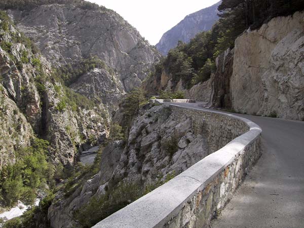
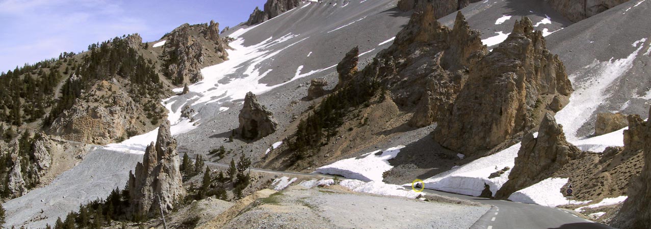
This pass rises high above the tree-level: you climb very fast, until the landscape is barren. The mountains of the Col de la Bonnette are not peaky: you get the sensation of riding between very high rolling hills, covered with grey rocks and snow.
When you go down, you can look very far ahead, because of the barrenness. Deep down, a dark forest appears.
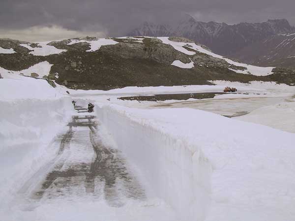
Try to be there in the beginning or the end of the season (with the chance of a closed pass, or only permitted from one side because only half of the width of the road is available because of the snow: on the bike, it's always interesting to try and see how far you can come when you see the sign "fermé"). Being alone there fits the rugged landscape much more than riding in heavy traffic.
Height: 2327 meters. The road is paved.
The Col de la Cayolle runs slightly west of the Col de la Bonnette, between
Barcelonnette
in the north, and
Guillaumes in the south.
Like the Col de la Bonnette, the Col de la Cayolle runs through the
Parc National du Mercantour
.
And like the Col de la Bonnette, the Col de la Cayolle is part of the Route des Grandes Alpes .
We started riding the Col de la Cayolle, in the end of may, when it was getting dark. That gave us the opportunity to spend the night in the Refuge de la Cayolle. Some photographs of the south side can be found on the page of day 2 of the Toscae trip .
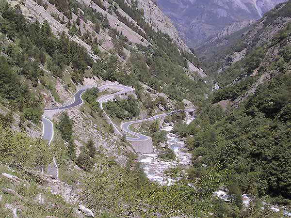
When you ride this pass north to south, you start on a gently sloping road, alongside a river, and with a rocky mountain at your left. This river
is the Var, and it's narrow and wild here.
The road is very narrow, and crosses the river from time to time. The vegetation is lush green. It's like riding through the jungle!
After a while, you leave the river (yes, it's a pity), and you start climbing steeper. When you are above the tree level, the landscape is competely different from the jungle below.
The way to the south, alogside black rocks (slate?), has spectacular views, and takes you fast down, in sweeping hairpins.
Shortly after the highest point, you will see the Refuge de la Cayolle (a very agreeable place to sleep or just eat or drink something!)
The highest point of the Col de Turini is 1607m. The road is paved.
The Col de Turini runs alongside the Parc National du Mercantour . And like the two cols above, the Cool de Turini is part of the Route des Grandes Alpes .
The Col de Turini plays an important part in the Rally de Monte Carlo.
The Col de Turini starts, in the north, with a dazzling series of haipins, going on and on. Finally, you end up riding in a gorge, with a wild
river on your left, and a steep rock-wall on your right.
This road ends in
Sospel, a very pleasant small town.
The height of the Col d'Izoard is 2360m. The road is paved.
The pass is situated between Briancon in the north, and Château Queyras in the south, and runs through the Parc naturel regional de Queyras .
The Col d'Izoard is part of the Route des Grandes Alpes.
In the beginning of june, we climbed the Col d'Izoard from the south. The weather was clear, so there are lots of photographs, on the page of day 10 of the Toscane trip (in Dutch).
Riding from the south, you ride alongside a river, for a long time. The river is wild, there are tunnels through rocks, vegetation is sparse: this is a wild country.
Then you start to climb, and at a certain moment you leave the forest: you enter the above-treelevel-area.
At that moment, there is a corner to the right, and when you turn around the rock, you see before you
enormous peaky rocks, like giant needles, sticking out of the slope of the mountain.
We saw them sticking out of the snow; in summer, the scene is equally impressive: they stick out of a desert landscape. This landscape is called
"La Casse deserte".
The way down, through a wood of firs and spruces, is pleasant: sweeping corners, and flowers next to the road.
Not far from the highest point of the pass is the Refuge Napoleon, a perfect place to drink or eat something, and stare at those incredible needles.
The height of the Col de la Croix de Fer is 2067m. The road is paved.
The pass is situated between St Jean de Maurienne in the north, and le Bourg d'Oisans in the south.
The Col de la Croix de Fer is part of the Route des Grandes Alpes.
In the beginning of june, we rode the Col de la Croix de Fer from the south. You will find photographs on the page of day 10 of the Toscane trip (in Dutch).
We came from the south, and from that side, you approach the pass by a narrow road, accompanied by a stream.
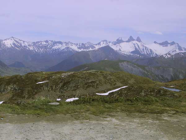
The actual pass starts after you left the trees behind. The climb is rather straight (for an Alpine pass, that is): it's the view on top of this pass that makes it such a special place. There is a plateau, from where you can look around you. Everywhere peaks of snowy mountains. With a map at hand, you can point out every single peak.
Riding down to the north, you keep these magnificent views for a long time, while riding in big sweeping hairpins.
The height of the Cormet de Roselend is 1968m. It is situated between Bourg st Maurice (in the southeast) and Beaufort (in the northwest) (from the Beaufort cheese).
The Cormet de Roselend is part of the Route des Grandes Alpes.
We rode the Cormet de Roselend in the first half of June, starting in Bourg st Maurice. You find photographs on the page of day 11 of the Toscane trip.
The road is narrow, and climbs through a wild landscape of forests, streams, rocks and falls. Above the treelevel, you are able to see the Mont Blanc in the east, as an archetype of a mountain, with a snowy white cap. You have to be luckyk, though: the Mont Blanc tends to cover itself in mist!
A little to the northwest of the highest point of the Cormet de Roselend is a path to the Auberge de la Nova , where you can eat delicious "mountain food", and sleep. A very special place to spend the night!
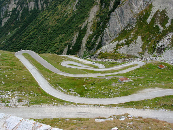
The height of the Susten pass is 2259m. The road is paved (very good and broad asfalt).
The pass runs between Wassen in the east and Meiringen in the west.
We rode the pass in the second half of september. We had the road for ourselves then!
You can find photographs on day 5 of the Intermot trip (in Dutch).
From Wassen on, the road climbs fast: lovely hairpins. The landscape soon become high alpine: some grass, barren rocks, snow. Many many corners where you can see through: this is circuitriding in the wild.
The attraction of this pass is the enormous gletcher that you can see in the south: bluegreen ice, cold, old, inhuman. The gletcher ends in a lake (frozen when we were there). It's a great sight, and there are several points from where you can enjoy it.
The way down (to the west) is again a hairpin-feast on good asfalt.
At the highest point of the pass, at the opposite side of a small lake, is the Sustenpass Hospiz, where you can eat a hearty meal, or stay the night.
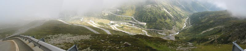
The highest point of the Grimsel Pass is at 2165m. The pas is paved (very good and broad asfalt). The pass is situated between the Susten pass in the north, and the Furka pass (starting in the valley of the Rhone) in the south.
We rode the Grimsel in september. It was a bit misty on the top, but there are enough photographs without mist on the page about day 5 of the Intermot trip (in Dutch).
When you ride the Grimsel pass from the north, you start in the valley of the Aare. One sweeping curve follows another, and you ride between green pastures and trees.
Then you start climbing, in hairpins, and when the landscape becomes barren, you get to see concrete walls of dams, on your right hand side. Very weird.
The highest dam is almost at the top. Behind this dam is a lake.
The road to the south is again superb motorcycle riding stuff (when there is little other traffic!).
On top of the highest dam is a road leading to a hospiz . On top of the pass are more hotels and restaurants. We didn't try any of them (not even for food or drink), so I can't tell anything about agreeableness.
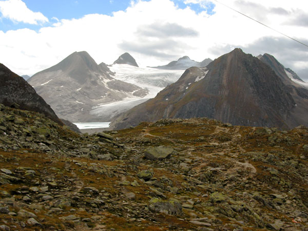
The height of the Nufenen pass is 2478m. The road is paved.
We rode the Nufenen in september, from the west to the east. Lots of photographs on the page of day 5 of the Intermot story.
The Nufenen starts, in the west, alongside a stream. A wild stream, in a wild valley. Loose rocks everywhere, and the road sweeps along.
Then the hairpin section starts, and takes you quickly higher. Good vision everywhere: this is magnificent motorcycle riding.
On the top, the colours are marvelous (brown and green mossy stones, white snow). The Nufenen is my favourite pass because of this landscape.
Going down means many many sweeping corners.
The height of the old st Gotthard pass is 2108m. The pass runs, like the new one, between Airolo in the south, and the Furka pass in the north. For the old pass, follow the signs for Tremola.
We rode this pass in september, on a clear and sunny day. Photographs on the page on day 5 of the Intermot trip.
The landscape
Coming from the Nufenen, you can choose for the tunnel or the old pass. The old pass immediately starts to climb. You ride cobblestondes hairpins.
There is a confusing point a little bit further, where the only way to the st Gotthard pass seems to be the new, broad, asfalted road, but that one will take you through the tunnel: follow the signs to Tremola.
I am very glad that this old pass is still maintained: there aren't that many cobblestoned roads through the Alps! Somehow, you feel more *in* the landscape, that way.
The road climbs, with steep, narrow hairpins, and eventually you will arrive at the Gotthard Hospiz , where you will meet everybody who used the new road to come there. Of course, you could use the new road to go down and up again too: it's the choice between riding a narrow, steep road with rough surface, with probably no other traffic, and a wide road, with circuit-like asfalt and very good curves, but most of the time with many cars.
For the road down (to the north) you can follow the old road again. This time, it will take you about halfway: then you join the new road, for the rest of the descent.
The Gotthard Hospiz is a very cosy place, situated at a lake. You can sleep there as well (didn't try that).
There is a museum, showing the history of the pass.
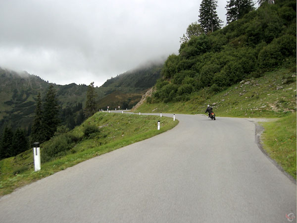
The height of the Furkajoch is 1761m. It is located between Schoppernau in the east (jn the Lech valley) and Rankweil in the west.
We rode the Furkajoch in september, at the end of the day. Some photographs on the page of day 4 of the Intermot trip.
The beginning and the end of the Furkajoch are in a typical Austrian landscape: green, farmersland, rolling hills, cows, farmer houses.
The road is narrow, the surface of the road is worn. The landscape is not spectacular, but especially when you are alone on the road (this is not a heavily used pass), you really feel "away from it all" here.
The way down to the west gives you a great view of the road below you, curving and curving.
The height of the Colle della Lombarda is 2351m. It is situated between Vinadio in Italy, in the north-east, and Isola 2000 in France, in the south-west.
We rode the pass in the beginning of june, on a sunny day. Photographs are on the page on day 9 of the Toscane story.
The narrow road leading to the pass, in Italy (no signposts telling you that this road leads to the Colle della Lombarde), is signposted as "dangerous". The road is very narrow, and there are many blind curves, so there is some truth in those signs.
This road leads you alongside a stream, with falls and rapids. There are steep dark grey rocks and many loose stones, and green shrubbery. Stunning. And all the time, you have to watch for Italian oncoming drivers supposing there is plenty of room on the road for both them and you, which is certainly not the case!
The road climbs fast, and when it takes you above the tree-level there are less blind corners, and more views. The road crinkles and crinkles, and from time to time you have stunning views when you look down, behind you.
Then you enter high Alpine country, with snow and rocks and nothing more. Majestic mountains.
On the top, you enter France. Not very far below, there is the ski-resort of Isola. From there, the road widens, the asfalt is of very good quality, the scenery turns into a wood, and there is nothing beautiful or spectacular anymore.
The Italian part is one of the most beautiful passes that I know of; the French part one of the dullest.


 Onderschrift
Conditions for the use of a photograph.
the Copyright page.
Onderschrift
Conditions for the use of a photograph.
the Copyright page. Code voor foto: